

The Council Creek Regional Trail is a collaboration between:
The Council Creek Regional Trail master plan was prepared in 2015. This document shows the future route of this planned 15 mile trail between the Hatfield MAX station in downtown Hillsboro and the Banks-Vernonia trailhead in Banks.
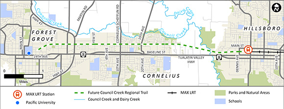
The proposed trail will be built in segments. The first six-mile segment, shown in the above map, follows abandoned railroad tracks.
Our planning process included public comment opportunities through online and in-person open houses and tables at community events.
Based on community input, we are going to build a trail that:
The trail will replace the unused railroad tracks along the designated trail route. Replacing the existing tracks makes construction easier and avoids environmentally sensitive areas.
This open house looks at the proposed design for the six-mile east-west trail segment between downtown Hillsboro and downtown Forest Grove.